1953 Map of Hartwell
USGS Topo · Published 1955About this map
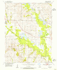
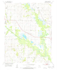
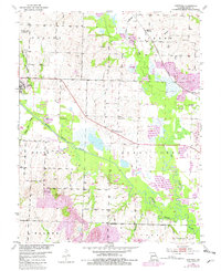
Hartwell and Urich anchor this mid-century portrait of Henry County, where the landscape is defined by the winding course of the South Grand River and its complex marshy bottomlands. The presence of the Old Channel South Grand River highlights a history of natural or engineered course changes through the floodplain, while the St Louis San Francisco railroad provides the primary industrial artery for the region.
Find a feature on this map
28 named features on this map. Tap any name to fly to it.
Don’t see what you’re looking for? This feature index may not catch every label — zoom into the map to look around manually.
Map Details
Editions of this 1953 Hartwell Map
3 editions found
Other maps of this area

1885 · Warrensburg
USGS Topo · 1:125,000

1887 · Clinton
USGS Topo · 1:125,000

1887 · Harrisonville
USGS Topo · 1:125,000

1887 · Butler
USGS Topo · 1:125,000

1887 · Warrensburg
USGS Topo · 1:125,000

1892 · Harrisonville
USGS Topo · 1:125,000

1894 · Harrisonville
USGS Topo · 1:125,000

1894 · Butler
USGS Topo · 1:125,000

1894 · Warrensburg
USGS Topo · 1:125,000

1894 · Clinton
USGS Topo · 1:125,000