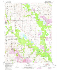
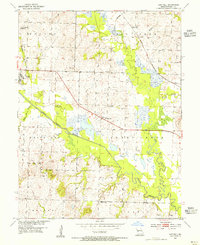
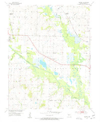
1953 Map of Hartwell
USGS Topo · Published 1982About this map
Maurine and Hartwell serve as small rural hubs in this Henry County landscape, where the South Grand River and its Old Channel dominate the drainage patterns. The map captures a moment of transition in land use, showing several identified Mines and a designated Reclaimed Area alongside the Urich State Wildlife Area. This intersection of industrial extraction and environmental conservation reflects the region's mid-century economic shifts. Genealogists will find a wealth of local landmarks, including the Enterprise Sch (Abandoned), the Hartwell Ch, and several family or community burial grounds such as Mickey Grove Cem and Norris Cem. The transportation corridor of the Burlington Northern railroad cuts through the terrain, linking the settlement at Urich to the surrounding township of Bogard.
Find a feature on this map
31 named features on this map. Tap any name to fly to it.
Don’t see what you’re looking for? This feature index may not catch every label — zoom into the map to look around manually.
Map Details
Editions of this 1953 Hartwell Map
3 editions found
Other maps of this area

1885 · Warrensburg
USGS Topo · 1:125,000

1887 · Clinton
USGS Topo · 1:125,000

1887 · Harrisonville
USGS Topo · 1:125,000

1887 · Butler
USGS Topo · 1:125,000

1887 · Warrensburg
USGS Topo · 1:125,000

1892 · Harrisonville
USGS Topo · 1:125,000

1894 · Harrisonville
USGS Topo · 1:125,000

1894 · Butler
USGS Topo · 1:125,000

1894 · Warrensburg
USGS Topo · 1:125,000

1894 · Clinton
USGS Topo · 1:125,000