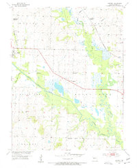
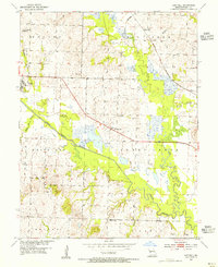
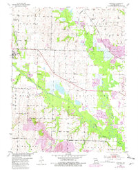
1953 Map of Hartwell
USGS Topo · Published 1955About this map
The South Grand River and its meandering tributaries, including Big Creek, dictate the landscape of Henry County in the early 1950s. The town of Urich serves as a primary hub in the west, while the smaller settlement of Hartwell sits further east along a corridor marked by the St Louis San Francisco railroad. This rail-and-river network supported a rural economy of agriculture and extraction, evidenced by scattered mines and a Strip Mine in the northeastern reaches. Local history is deeply etched into the topography through a network of rural institutions, such as Hartwell Ch and the already Enterprise Sch (Abandoned). The presence of family and community landmarks like Norris Cem, Morgan Cem, and Marvin Sch provides a tangible record of the families who settled these townships before modern development altered the course of the Old Channel.
Find a feature on this map
31 named features on this map. Tap any name to fly to it.
Don’t see what you’re looking for? This feature index may not catch every label — zoom into the map to look around manually.
Map Details
Editions of this 1953 Hartwell Map
3 editions found
Other maps of this area

1885 · Warrensburg
USGS Topo · 1:125,000

1887 · Clinton
USGS Topo · 1:125,000

1887 · Harrisonville
USGS Topo · 1:125,000

1887 · Butler
USGS Topo · 1:125,000

1887 · Warrensburg
USGS Topo · 1:125,000

1892 · Harrisonville
USGS Topo · 1:125,000

1894 · Harrisonville
USGS Topo · 1:125,000

1894 · Butler
USGS Topo · 1:125,000

1894 · Warrensburg
USGS Topo · 1:125,000

1894 · Clinton
USGS Topo · 1:125,000