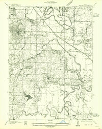
1955 Map of Rich Hill
USGS Topo · Published 1955About this map
The Rich Hill street grid dominates the northwestern corner of this landscape, serving as a hub for the surrounding rural settlements and industrial sites. The region is defined by the complex hydrology of the Osage River, Little Osage River, and Marmaton River, which create a labyrinth of sloughs and backwaters like Ingram Slash and Eggleston Slough. Just south of the main township, the Monnum Mines and the small community at Carbon Center highlight the area’s coal mining history during the mid-1930s survey period.
Find a feature on this map
44 named features on this map. Tap any name to fly to it.
Don’t see what you’re looking for? This feature index may not catch every label — zoom into the map to look around manually.
Map Details
Editions of this 1955 Rich Hill Map
This is the sole edition of this map. No revisions or reprints were ever made.
Other maps of this area

1886 · Nevada
USGS Topo · 1:125,000

1887 · Butler
USGS Topo · 1:125,000

1894 · Butler
USGS Topo · 1:125,000

1894 · Nevada
USGS Topo · 1:125,000

1934 · Papinsville
USGS Topo · 1:24,000

1936 · Rich Hill
USGS Topo · 1:24,000

1937 · New Home
USGS Topo · 1:24,000

1938 · Metz
USGS Topo · 1:24,000

1938 · Horton
USGS Topo · 1:24,000

1939 · Metz
USGS Topo · 1:24,000