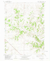
1981 Map of Pleasant Grove
USGS Topo · Published 1981About this map
Flint River drainage and the rolling agricultural lands of northern Des Moines County define this 1981 survey. The landscape is dotted with small family-named burial sites, including the Gallihar Cem and Butcher Cem, which offer significant value for genealogists tracing local lineage in Pleasant Grove and Washington townships. The map records a rural infrastructure of bridge crossings like BR 657 and the diagonal transit of the Burlington Northern railroad in the southwest corner near Roadside Park. Numerous watercourses, such as Cottonwood Creek and Cedar Fork, carve through the terrain, illustrating the natural drainage patterns that shaped the settlement of small communities like Hanks and Pleasant Grove.
Find a feature on this map
33 named features on this map. Tap any name to fly to it.
Don’t see what you’re looking for? This feature index may not catch every label — zoom into the map to look around manually.
Map Details
Editions of this 1981 Pleasant Grove Map
This is the sole edition of this map. No revisions or reprints were ever made.
Other maps of this area

1934 · Burlington
USGS Topo · 1:48,000

1940 · Burlington
USGS Topo · 1:62,500

1946 · Wapello
USGS Topo · 1:62,500

1949 · Wapello
USGS Topo · 1:62,500

1958 · Burlington
USGS Topo · 1:250,000

1958 · Davenport
USGS Topo · 1:250,000

1961 · Burlington
USGS Topo · 1:250,000

1961 · Davenport
USGS Topo · 1:250,000

1962 · Davenport
USGS Topo · 1:250,000

1963 · Burlington
USGS Topo · 1:250,000