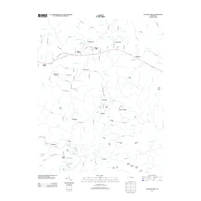
2013 Map of Pleasant Hill
USGS Topo · Published 2013About this map
Pleasant Hill sits at the center of this Tennessee landscape, where Highway 70 connects a series of small communities including Hickory Hills, The Meadows, and Claysville. The topography is defined by the winding course of the Caney Fork and its numerous tributaries, which have carved out distinct landmarks like Dark Hollow and Fox Hollow. To the south, the settlements of Clifty and Eastland are situated near the banks of Clifty Cr, reflecting a settlement pattern tied to the area's river and creek system.
Find a feature on this map
138 named features on this map. Tap any name to fly to it.
Don’t see what you’re looking for? This feature index may not catch every label — zoom into the map to look around manually.
Map Details
Editions of this 2013 Pleasant Hill Map
This is the sole edition of this map. No revisions or reprints were ever made.
Other maps of this area

1892 · Pikeville
USGS Topo · 1:125,000

1895 · Pikeville
USGS Topo · 1:125,000

1897 · Standingstone
USGS Topo · 1:125,000

1898 · Standingstone
USGS Topo · 1:125,000

1912 · Crossville
USGS Topo · 1:62,500

1935 · Isoline
USGS Topo · 1:24,000

1935 · Campbell Junction
USGS Topo · 1:24,000
1935 · Vandever
USGS Topo · 1:24,000
1936 · Crossville
USGS Topo · 1:24,000

1943 · Cookeville
USGS Topo · 1:100,000