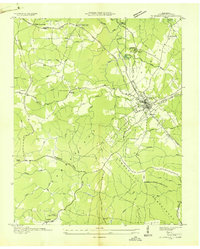
1936 Map of Crossville
USGS Topo · Published 1936About this map
Crossville serves as the hub of this 1936 survey, where the Tennessee Central Ry Co and the Alvin C York Highway converge atop the Cumberland Plateau. The landscape reveals a critical moment in regional development, notably featuring the Cumberland Homesteads project in the south, a New Deal-era subsistence farming community. The map details a network of rural education and faith, identifying the Cumberland Mountain Sch, Oak Grove Sch, and Roberts Chapel.
Find a feature on this map
57 named features on this map. Tap any name to fly to it.
Don’t see what you’re looking for? This feature index may not catch every label — zoom into the map to look around manually.
Map Details
Editions of this 1936 Crossville Map
This is the sole edition of this map. No revisions or reprints were ever made.
Other maps of this area

1887 · Kingston
USGS Topo · 1:125,000

1891 · Kingston
USGS Topo · 1:125,000

1892 · Pikeville
USGS Topo · 1:125,000

1893 · Kingston
USGS Topo · 1:125,000

1895 · Wartburg
USGS Topo · 1:125,000

1895 · Pikeville
USGS Topo · 1:125,000

1896 · Wartburg
USGS Topo · 1:125,000

1897 · Standingstone
USGS Topo · 1:125,000

1898 · Standingstone
USGS Topo · 1:125,000

1912 · Crossville
USGS Topo · 1:62,500