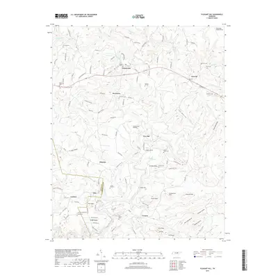
2019 Map of Pleasant Hill
USGS Topo · Published 2019About this map
Pleasant Hill and the surrounding high country of the Cumberland Plateau are detailed in this survey of the Tennessee highlands. The landscape is defined by the Tennessee Valley Divide, where the headwaters of Caney Fork and its tributaries like Clifty Cr and Meadow Cr carve deep hollows such as Dark Hollow and George Hollow. The map reveals a dense network of family-named landmarks and rural infrastructure, from the Old Railroad Grade Rd near Eastland to numerous local burial grounds including Smith Chapel Cem and Van Winkle Cem. Small settlements like Browntown, Ridgedale, and Erasmus are connected by a web of mountain roads, reflecting the persistent rural character of Cumberland County. The terrain is punctuated by distinctive high points like Officer Knob and Pilot Knob, which overlook the complex drainage basins feeding into the central river system.
Find a feature on this map
128 named features on this map. Tap any name to fly to it.
Don’t see what you’re looking for? This feature index may not catch every label — zoom into the map to look around manually.
Map Details
Editions of this 2019 Pleasant Hill Map
This is the sole edition of this map. No revisions or reprints were ever made.
Other maps of this area

1892 · Pikeville
USGS Topo · 1:125,000

1895 · Pikeville
USGS Topo · 1:125,000

1897 · Standingstone
USGS Topo · 1:125,000

1898 · Standingstone
USGS Topo · 1:125,000

1912 · Crossville
USGS Topo · 1:62,500

1935 · Isoline
USGS Topo · 1:24,000

1935 · Campbell Junction
USGS Topo · 1:24,000
1935 · Vandever
USGS Topo · 1:24,000
1936 · Crossville
USGS Topo · 1:24,000

1943 · Cookeville
USGS Topo · 1:100,000