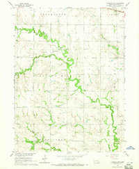
1964 Map of Pleasant Hill
USGS Topo · Published 1965About this map
Turkey Creek and its many tributaries, including Coon Creek and Spring Creek, wind through this mid-1960s portrait of rural Saline County. The landscape is defined by the township structure, showing the districts of Dorchester, Crete, Pleasant Hill, Brush Creek, and Wilber. At the center of this social and agricultural network sits the settlement of Pleasant Hill, accompanied by the Pleasant Hill Cem and a Community Hall. The map reveals a high density of rural education sites, with local landmarks like Red Brick Sch, Evergreen Sch, and Willow Bend Sch serving as cornerstones for the farming families of the era. To the northeast, the C B & Q railroad line skims across the corner near the Big Blue River, linking this productive agrarian region to larger trade networks.
Find a feature on this map
21 named features on this map. Tap any name to fly to it.
Don’t see what you’re looking for? This feature index may not catch every label — zoom into the map to look around manually.
Map Details
Editions of this 1964 Pleasant Hill Map
This is the sole edition of this map. No revisions or reprints were ever made.
Other maps of this area

1897 · Lincoln
USGS Topo · 1:125,000

1935 · Dorchester
USGS Topo · 1:48,000

1940 · Dorchester
USGS Topo · 1:62,500

1955 · Lincoln
USGS Topo · 1:250,000

1957 · Lincoln
USGS Topo · 1:250,000

1957 · Wilber
USGS Topo · 1:24,000

1958 · Lincoln
USGS Topo · 1:250,000

1961 · Western
USGS Topo · 1:24,000
1961 · Swanton
USGS Topo · 1:24,000
1964 · Crete South
USGS Topo · 1:24,000