
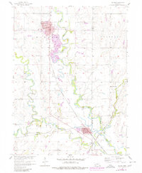
1957 Map of Wilber
USGS Topo · Published 1958About this map
The Big Blue River meanders through the heart of this Saline County landscape, defining the topography around the communities of Wilber and De Witt. During the late 1950s, this region remained a vital intersection of rail and river commerce, served by the Chicago Burlington and Quincy and the Chicago Rock Island and Pacific railroads. The grid of Wilber shows the town's established structure as a local hub, while the surrounding countryside is dotted with numerous rural schools and community landmarks.
Find a feature on this map
26 named features on this map. Tap any name to fly to it.
Don’t see what you’re looking for? This feature index may not catch every label — zoom into the map to look around manually.
Map Details
Editions of this 1957 Wilber Map
2 editions found
Other maps of this area

1897 · Lincoln
USGS Topo · 1:125,000

1935 · Dorchester
USGS Topo · 1:48,000

1940 · Dorchester
USGS Topo · 1:62,500

1955 · Lincoln
USGS Topo · 1:250,000

1957 · Lincoln
USGS Topo · 1:250,000

1957 · Plymouth
USGS Topo · 1:24,000

1957 · Clatonia
USGS Topo · 1:24,000

1957 · Beatrice West
USGS Topo · 1:24,000

1958 · Lincoln
USGS Topo · 1:250,000

1961 · Western SE
USGS Topo · 1:24,000