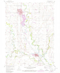
1957 Map of Wilber
USGS Topo · Published 1980About this map
The Big Blue River meanders through this Saline County landscape, anchoring the settlements of Wilber and De Witt during a period of mid-century growth. This 1957 survey, updated with 1978 aerial revisions, highlights the rail-dependent economy of the region, where the Chicago Burlington and Quincy and the Chicago Rock Island and Pacific railroads intersect near the river's path. The map reveals a dense network of rural community landmarks, including the Czech Slovansky Cem and several numbered schoolhouses like School No 5 and School No 7. The presence of a Wilber Municipal Landing Field and a separate Landing Strip near the river indicates the local importance of small-scale aviation. Geologic extraction is noted through several sites, including a Gravel Pit along the riverbanks, while agricultural townships like Clatonia and Grant define the surrounding plains.
Find a feature on this map
26 named features on this map. Tap any name to fly to it.
Don’t see what you’re looking for? This feature index may not catch every label — zoom into the map to look around manually.
Map Details
Editions of this 1957 Wilber Map
2 editions found
Other maps of this area

1897 · Lincoln
USGS Topo · 1:125,000

1935 · Dorchester
USGS Topo · 1:48,000

1940 · Dorchester
USGS Topo · 1:62,500

1955 · Lincoln
USGS Topo · 1:250,000

1957 · Lincoln
USGS Topo · 1:250,000

1957 · Plymouth
USGS Topo · 1:24,000

1957 · Clatonia
USGS Topo · 1:24,000

1957 · Beatrice West
USGS Topo · 1:24,000

1957 · Wilber
USGS Topo · 1:24,000

1958 · Lincoln
USGS Topo · 1:250,000