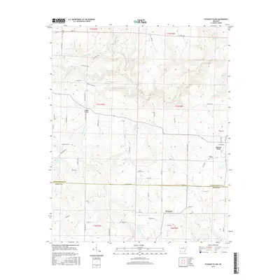
2017 Map of Pleasant Plains
USGS Topo · Published 2017About this map
The borderlands of Independence Co and White Co reveal a landscape defined by an intricate network of waterways and rural settlements. Pleasant Plains serves as a primary anchor in the east, while the smaller communities of Cedar Grove and Roosevelt are connected by a web of local roads such as Cedar Grove Rd and Roosevelt Rd. The drainage patterns here are complex, with Salado Creek carving through the northern sections and Tenmile Creek winding through the center, eventually joined by numerous tributaries like Mitchell Br and Wagon Wheel Creek. Genealogists will find significance in several burial grounds, including Old Union Cem and the Pleasant Plains Cem, which provide a geographic context for the area's long-standing families. The terrain transitions into the southern reaches via Fourteenmile Creek and Cypress Creek, illustrating the heavy influence of the watershed on the region's development.
Find a feature on this map
73 named features on this map. Tap any name to fly to it.
Don’t see what you’re looking for? This feature index may not catch every label — zoom into the map to look around manually.
Map Details
Editions of this 2017 Pleasant Plains Map
This is the sole edition of this map. No revisions or reprints were ever made.
Other maps of this area

1890 · Batesville
USGS Topo · 1:125,000

1891 · Batesville
USGS Topo · 1:125,000

1935 · Bald Knob
USGS Topo · 1:62,500

1942 · Jamestown
USGS Topo · 1:31,680

1942 · Almond
USGS Topo · 1:31,680

1942 · Salado
USGS Topo · 1:31,680

1953 · Memphis
USGS Topo · 1:250,000

1956 · Memphis
USGS Topo · 1:250,000

1962 · Pangburn
USGS Topo · 1:24,000
1965 · Salado
USGS Topo · 1:24,000