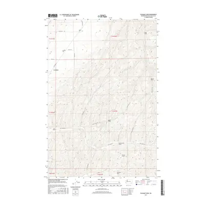
2017 Map of Pleasant View
USGS Topo · Published 2017About this map
Skyrocket Hills define the southern reaches of this landscape in Walla Walla County, where the terrain breaks into a complex network of canyons and hollows. The settlement of Tompkins sits near the intersection of Lyons Ferry Rd and Tomkins Rd, marking a point of long-standing local transit. To the north, the plateau opens into Eureka Flat, a distinct geographical feature that contrasts with the deep incisions of Winnett Canyon and Badger Hollow found further south. This 2017 survey details a rural environment dominated by agricultural land use and natural drainage patterns, such as Smith Springs which flows through Smith Springs Hollow. The map provides an intricate view of the local road network, including Barstow Rd and Manuel Hollow Rd, which follow the natural contours of the high country near Pleasant View.
Find a feature on this map
27 named features on this map. Tap any name to fly to it.
Don’t see what you’re looking for? This feature index may not catch every label — zoom into the map to look around manually.
Map Details
Editions of this 2017 Pleasant View Map
This is the sole edition of this map. No revisions or reprints were ever made.
Other maps of this area

1919 · Walla Walla
USGS Topo · 1:125,000

1921 · Walla Walla
USGS Topo · 1:125,000

1948 · Starbuck
USGS Topo · 1:62,500

1948 · Ayer
USGS Topo · 1:62,500

1950 · Starbuck
USGS Topo · 1:62,500

1950 · Haas
USGS Topo · 1:62,500

1953 · Walla Walla
USGS Topo · 1:250,000

1958 · Walla Walla
USGS Topo · 1:250,000
1967 · Prescott
USGS Topo · 1:24,000

1967 · Waitsburg NW
USGS Topo · 1:24,000