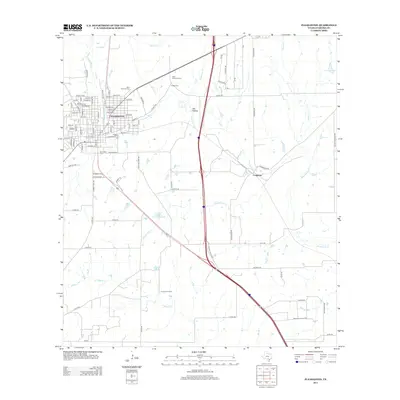
2013 Map of Pleasanton
USGS Topo · Published 2013About this map
Pleasanton serves as the focal point of this South Texas landscape, where a dense street grid organized around Depot St and N Main St meets the winding course of the Atascosa River. The map captures the town's expansion toward the northeast, bordered by the riparian woodlands of Oak Hollow and several prominent local burial grounds including Saint Andrews Cem and Sotelo Cem.
Find a feature on this map
100 named features on this map. Tap any name to fly to it.
Don’t see what you’re looking for? This feature index may not catch every label — zoom into the map to look around manually.
Map Details
Editions of this 2013 Pleasanton Map
This is the sole edition of this map. No revisions or reprints were ever made.
Other maps of this area

1953 · Crystal City
USGS Topo · 1:250,000

1954 · San Antonio
USGS Topo · 1:250,000

1955 · Crystal City
USGS Topo · 1:250,000

1956 · Pleasanton
USGS Topo · 1:62,500

1956 · Jourdanton
USGS Topo · 1:62,500

1957 · San Antonio
USGS Topo · 1:250,000

1961 · Crystal City
USGS Topo · 1:250,000
1964 · Saspamco SE
USGS Topo · 1:24,000

1964 · Leming
USGS Topo · 1:24,000

1968 · Crystal City
USGS Topo · 1:250,000