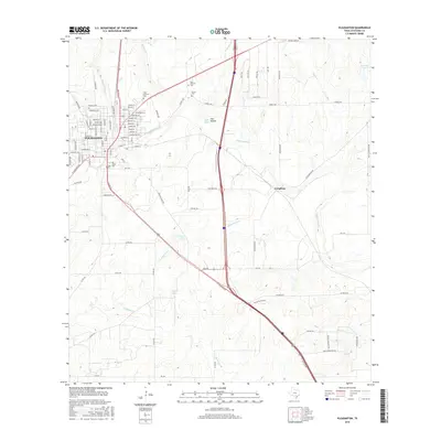
2016 Map of Pleasanton
USGS Topo · Published 2016About this map
Pleasanton sits at the western edge of this South Texas landscape, where the Atascosa River and its many tributaries, such as Bonita Cr and Georgetown Cr, carve through the terrain. The map documents the city's residential street grid alongside outlying settlements like Coughran. For genealogists and local historians, several burial sites are clearly marked, including Saint Andrews Cem, Sotelo Cem, and San Ysidro Cem. The hydrologic character of the region is defined by several small bodies of water, including Quillian Lake, Williams Lake, and the Oak Hollow reservoir. The convergence of numerous county roads and local thoroughfares like Plestex Ave and Eurostar Dr reflects the modern development of Atascosa County as it expands from its traditional ranching and river-centered roots.
Find a feature on this map
95 named features on this map. Tap any name to fly to it.
Don’t see what you’re looking for? This feature index may not catch every label — zoom into the map to look around manually.
Map Details
Editions of this 2016 Pleasanton Map
This is the sole edition of this map. No revisions or reprints were ever made.
Other maps of this area

1953 · Crystal City
USGS Topo · 1:250,000

1954 · San Antonio
USGS Topo · 1:250,000

1955 · Crystal City
USGS Topo · 1:250,000

1956 · Pleasanton
USGS Topo · 1:62,500

1956 · Jourdanton
USGS Topo · 1:62,500

1957 · San Antonio
USGS Topo · 1:250,000

1961 · Crystal City
USGS Topo · 1:250,000
1964 · Saspamco SE
USGS Topo · 1:24,000

1964 · Leming
USGS Topo · 1:24,000

1968 · Crystal City
USGS Topo · 1:250,000