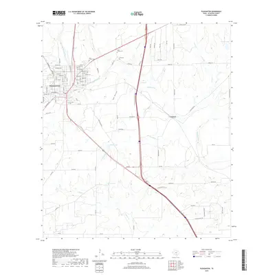
2019 Map of Pleasanton
USGS Topo · Published 2019About this map
The Atascosa River flows southeast through this portion of Atascosa County, anchoring a landscape defined by its riparian corridors and small agricultural settlements. The city of Pleasanton occupies the northwest corner, showing a detailed street grid including Uvalde St and Dallas St, while the community of Coughran sits further east near the center of the sheet. The area's history is preserved in local burial grounds such as Saint Andrews Cem, Sotelo Cem, and San Ysidro Cem, which serve as vital markers for genealogical research.
Find a feature on this map
88 named features on this map. Tap any name to fly to it.
Don’t see what you’re looking for? This feature index may not catch every label — zoom into the map to look around manually.
Map Details
Editions of this 2019 Pleasanton Map
This is the sole edition of this map. No revisions or reprints were ever made.
Other maps of this area

1953 · Crystal City
USGS Topo · 1:250,000
1954 · San Antonio
USGS Topo · 1:250,000

1955 · Crystal City
USGS Topo · 1:250,000
1956 · Pleasanton
USGS Topo · 1:62,500
1956 · Jourdanton
USGS Topo · 1:62,500
1957 · San Antonio
USGS Topo · 1:250,000
1961 · Crystal City
USGS Topo · 1:250,000
1964 · Saspamco SE
USGS Topo · 1:24,000
1964 · Leming
USGS Topo · 1:24,000

1968 · Crystal City
USGS Topo · 1:250,000