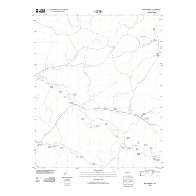
2010 Map of Pleasantville
USGS Topo · Published 2010About this map
Upper Sinking Creek and Cane Creek dominate this landscape, where the deeply dissected plateau creates a complex network of hollows that define the region's historical geography. Named families left their mark on the terrain through features like McClearen Hollow, Rickman Hollow, and Sugarcamp Hollow. Settlement patterns are anchored by the Pleasantville Post Office and Farmers Exchange, while the presence of the Chessor Mine and Coble Lookout Tower point to the area's extraction and forest management history.
Find a feature on this map
77 named features on this map. Tap any name to fly to it.
Don’t see what you’re looking for? This feature index may not catch every label — zoom into the map to look around manually.
Map Details
Editions of this 2010 Pleasantville Map
This is the sole edition of this map. No revisions or reprints were ever made.
Other maps of this area

1936 · Graves Spring
USGS Topo · 1:24,000

1936 · Pleasantville
USGS Topo · 1:24,000

1936 · Coble
USGS Topo · 1:24,000

1936 · Beaverdam Springs
USGS Topo · 1:24,000

1936 · Whitfield
USGS Topo · 1:24,000

1936 · Linden
USGS Topo · 1:24,000

1936 · Chestnut Grove
USGS Topo · 1:24,000

1936 · Lobelville
USGS Topo · 1:24,000

1936 · Kimmins
USGS Topo · 1:24,000
1950 · Linden
USGS Topo · 1:24,000