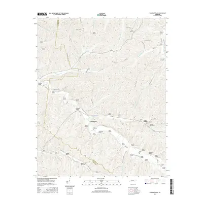
2016 Map of Pleasantville
USGS Topo · Published 2016About this map
Pleasantville serves as the central hub of this Tennessee landscape, where the deeply dissected plateau of the Western Highland Rim is defined by a dense network of hollows and family-named landmarks. The drainage patterns of Cane Creek and its many tributaries, such as Upper Sinking Cr, dictate the placement of roads and homesteads. Local history is preserved in numerous family burial grounds, including Beech Grove Cem, Ayers Cem, and Williams Cem, which are scattered throughout the hills near settlements like Upper Sinking. The naming of areas like Powder Mill Hollow Rd hints at the historical industries that once utilized the region's timber and water resources. This survey illustrates a rural social geography where topographic features like Negro Hollow, Jones Hollow, and Sugarcamp Hollow remain primary identifiers for the land and its residents.
Find a feature on this map
98 named features on this map. Tap any name to fly to it.
Don’t see what you’re looking for? This feature index may not catch every label — zoom into the map to look around manually.
Map Details
Editions of this 2016 Pleasantville Map
This is the sole edition of this map. No revisions or reprints were ever made.
Other maps of this area

1936 · Graves Spring
USGS Topo · 1:24,000

1936 · Pleasantville
USGS Topo · 1:24,000

1936 · Coble
USGS Topo · 1:24,000

1936 · Beaverdam Springs
USGS Topo · 1:24,000

1936 · Whitfield
USGS Topo · 1:24,000

1936 · Linden
USGS Topo · 1:24,000

1936 · Chestnut Grove
USGS Topo · 1:24,000

1936 · Lobelville
USGS Topo · 1:24,000

1936 · Kimmins
USGS Topo · 1:24,000
1950 · Linden
USGS Topo · 1:24,000