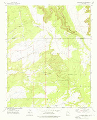
1972 Map of Plumasano Basin
USGS Topo · Published 1976About this map
The Zuni Indian Reservation occupies the central and northern reaches of this New Mexico landscape, characterized by the expansive Plumasano Basin. Surveyed in the early 1970s, the map delineates significant administrative and historical markers, including the Old Indian Reservation Boundary and the dividing line between Mc Kinley and Valencia Counties. The terrain is defined by prominent high ground such as Red Mesa and Pie Mesa, which overlook a network of seasonal watercourses. Drainage patterns are established by Plumasano Wash, Willow Wash, and Thompson Draw, reflecting the arid hydrology of the region. These features, along with isolated landmarks like Spring in Mullen Canyon, provide essential context for understanding the historic land use and tribal geography of this high-desert territory.
Find a feature on this map
11 named features on this map. Tap any name to fly to it.
Don’t see what you’re looking for? This feature index may not catch every label — zoom into the map to look around manually.
Map Details
Editions of this 1972 Plumasano Basin Map
This is the sole edition of this map. No revisions or reprints were ever made.
Other maps of this area

1886 · Wingate
USGS Topo · 1:250,000

1892 · Wingate
USGS Topo · 1:250,000

1954 · Saint Johns
USGS Topo · 1:250,000

1954 · Gallup
USGS Topo · 1:250,000

1957 · Saint Johns
USGS Topo · 1:250,000

1958 · Gallup
USGS Topo · 1:250,000

1958 · Saint Johns
USGS Topo · 1:250,000

1959 · Gallup
USGS Topo · 1:250,000

1962 · Gallup
USGS Topo · 1:250,000

1962 · Saint Johns
USGS Topo · 1:250,000