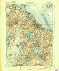
1939 Map of Plymouth
USGS Topo · Published 1939About this map
Plymouth shoreline and the surrounding glacial landscape of Kingston and Carver appear here during the late 1930s. The coastline is defined by the sweeping reach of Plymouth Beach and the distinct points of Saquish Head and Saquish Neck guarding the harbor. Inland, the terrain is densely marked by kettle ponds and bogs, including the expansive Billington Sea and several productive commercial tracts like Cushman Bog and Pratt Bog. The map captures the industrial and maritime character of the era, from the waterfront at Cordage and North Plymouth to the historic significance of Plymouth Rock and Coles Hill. Transportation networks such as the New York New Haven and Hartford RR and the Plymouth and Middleboro Road demonstrate the region's connection to larger Massachusetts trade hubs.
Find a feature on this map
75 named features on this map. Tap any name to fly to it.
Don’t see what you’re looking for? This feature index may not catch every label — zoom into the map to look around manually.
Map Details
Editions of this 1939 Plymouth Map
4 editions found
Other maps of this area

1885 · Abington
USGS Topo · 1:62,500

1885 · Duxbury
USGS Topo · 1:62,500

1885 · Middleboro
USGS Topo · 1:62,500

1886 · Plymouth
USGS Topo · 1:62,500

1888 · Duxbury
USGS Topo · 1:62,500

1888 · Middleboro
USGS Topo · 1:62,500

1888 · Abington
USGS Topo · 1:62,500

1889 · Plymouth
USGS Topo · 1:62,500

1893 · Abington
USGS Topo · 1:62,500

1893 · Duxbury
USGS Topo · 1:62,500