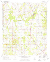
1971 Map of Pocahontas
USGS Topo · Published 1973About this map
Ancient earthworks and rural congregations anchor this early 1970s landscape along the border of Madison and Hinds counties. The settlement of Pocahontas is situated prominently along the Illinois Central railroad, distinguished by the Indian Mounds and the adjacent Pocahontas Mounds Roadside Park. The survey captures a network of small churches that served these communities, including Shady Grove Ch, Mt Zion Ch, and Bakers Grove Ch, reflecting the deep-seated social geography of the area.
Find a feature on this map
43 named features on this map. Tap any name to fly to it.
Don’t see what you’re looking for? This feature index may not catch every label — zoom into the map to look around manually.
Map Details
Editions of this 1971 Pocahontas Map
This is the sole edition of this map. No revisions or reprints were ever made.
Other maps of this area

1903 · Jackson
USGS Topo · 1:125,000

1905 · Jackson
USGS Topo · 1:48,000

1908 · Jackson
USGS Topo · 1:62,500

1934 · Raymond
USGS Topo · 1:48,000

1937 · Raymond
USGS Topo · 1:62,500

1942 · Raymond
USGS Topo · 1:62,500

1955 · Jackson
USGS Topo · 1:250,000

1961 · Jackson
USGS Topo · 1:250,000

1961 · Canton
USGS Topo · 1:62,500

1962 · Jackson
USGS Topo · 1:250,000