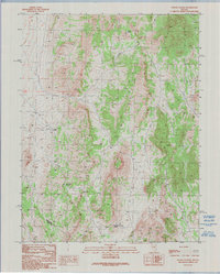
1990 Map of Pogues Station
USGS Topo · Published 1990About this map
Pogues Station serves as the focal point of this arid basin and range landscape on the boundary between White Pine and Nye counties. This 1990 provisional survey documents a high-desert environment where water sources like Soda Spring, Nevada Governors Spring, and a localized Spring were critical for survival and transit. The presence of numerous prospects and a Gravel Pit indicate a landscape defined by small-scale mineral exploration and resource extraction, common across this section of Nevada. The terrain is marked by significant elevation changes, most notably at Red Rock Summit, which overlooks the winding network of unimproved roads and 4WD tracks that connected these remote outposts. This map captures the persistent character of the Great Basin, where isolated landmarks and reliable water remained the primary features of the human footprint long after the initial mining booms.
Find a feature on this map
10 named features on this map. Tap any name to fly to it.
Don’t see what you’re looking for? This feature index may not catch every label — zoom into the map to look around manually.
Map Details
Editions of this 1990 Pogues Station Map
This is the sole edition of this map. No revisions or reprints were ever made.
Other maps of this area

1951 · Green Springs
USGS Topo · 1:62,500

1951 · Pancake Summit
USGS Topo · 1:62,500

1953 · Pinto Summit
USGS Topo · 1:62,500

1956 · Ely
USGS Topo · 1:250,000

1959 · Ely
USGS Topo · 1:250,000

1963 · Ely
USGS Topo · 1:250,000

1964 · Moody Peak
USGS Topo · 1:62,500

1979 · Mt. Hamilton
USGS Topo · 1:100,000

1990 · Pancake Summit SW
USGS Topo · 1:24,000
1990 · Green Springs NW
USGS Topo · 1:24,000