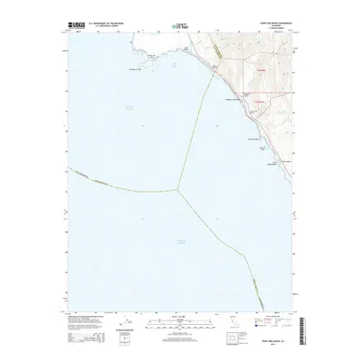
2015 Map of Point Ano Nuevo
USGS Topo · Published 2015About this map
Point Año Nuevo and the offshore Año Nuevo Island anchor this coastal survey where the San Mateo Co and Santa Cruz Co line meets the Pacific. The landscape is defined by the drainage of several small waterways, including Waddell Cr and Año Nuevo Cr, which carve through the coastal bluffs to reach the shoreline. Significant landmarks along the coast, such as Greyhound Rock and Pelican Rock, serve as distinct navigational points between more secluded spots like China Ladder Beach. Just inland from Waddell Creek Beach, the Las Trancas Airport represents a small pocket of infrastructure amidst the natural drainage basins of Laguna de las Francas and Arroyo de las Francas. The map illustrates a transitional zone where steep gulches like Wilson Gulch give way to the broader Año Nuevo Bay.
Find a feature on this map
34 named features on this map. Tap any name to fly to it.
Don’t see what you’re looking for? This feature index may not catch every label — zoom into the map to look around manually.
Map Details
Editions of this 2015 Point Ano Nuevo Map
This is the sole edition of this map. No revisions or reprints were ever made.
Other maps of this area

1902 · Santa Cruz
USGS Topo · 1:125,000

1940 · Ano Nuevo
USGS Topo · 1:62,500

1941 · Ano Nuevo Pt.
USGS Topo · 1:62,500

1942 · Ano Nuevo
USGS Topo · 1:62,500

1947 · San Francisco
USGS Topo · 1:250,000

1948 · San Francisco
USGS Topo · 1:250,000

1948 · Ano Nuevo
USGS Topo · 1:62,500

1955 · San Francisco
USGS Topo · 1:250,000
1955 · Pigeon Point
USGS Topo · 1:24,000
1955 · Ano Nuevo
USGS Topo · 1:24,000