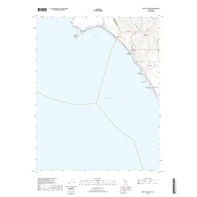
2018 Map of Point Ano Nuevo
USGS Topo · Published 2018About this map
Point Año Nuevo and the rugged coastal interface of the Santa Cruz Mountains define this segment of the Central California shoreline. The landscape is marked by a transition from the marine environment of Año Nuevo Bay and Año Nuevo Island to the upland terrain crossed by historical access routes like Last Chance Rd and Skyline to the Sea Trail Rd. Local aviation and ranching history are evident through the presence of the Las Trancas Airport and family-named thoroughfares such as Purdy Ranch Rd and Rw Pozzi Ranch Rd. The map also delineates the boundary between San Mateo and Santa Cruz counties, which follows the drainage of Waddell Creek down to Waddell Creek Beach. This coastal corridor remains largely undeveloped, preserved in part by the Cañada de la Salud and a network of footpaths including the Año Nuevo Point Trail.
Find a feature on this map
34 named features on this map. Tap any name to fly to it.
Don’t see what you’re looking for? This feature index may not catch every label — zoom into the map to look around manually.
Map Details
Editions of this 2018 Point Ano Nuevo Map
This is the sole edition of this map. No revisions or reprints were ever made.
Other maps of this area

1902 · Santa Cruz
USGS Topo · 1:125,000

1940 · Ano Nuevo
USGS Topo · 1:62,500

1941 · Ano Nuevo Pt.
USGS Topo · 1:62,500

1942 · Ano Nuevo
USGS Topo · 1:62,500

1947 · San Francisco
USGS Topo · 1:250,000

1948 · San Francisco
USGS Topo · 1:250,000

1948 · Ano Nuevo
USGS Topo · 1:62,500

1955 · San Francisco
USGS Topo · 1:250,000
1955 · Pigeon Point
USGS Topo · 1:24,000
1955 · Ano Nuevo
USGS Topo · 1:24,000