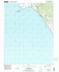
1997 Map of Point Ano Nuevo
USGS Topo · Published 1999About this map
Point Año Nuevo and its offshore companion Año Nuevo Island dominate this coastal survey along the border of San Mateo and Santa Cruz counties. The landscape is defined by its conservation status, with significant acreage dedicated to the Año Nuevo State Reserve and the southern reaches of Big Basin Redwoods State Park. This late 20th-century edition illustrates a coast largely preserved from dense residential development, characterized instead by state wilderness areas and natural preserves. Inland from the Pacific Ocean, the land rises toward the West Waddell Creek State Wilderness, where a network of drainages including Waddell Creek and Finney Creek carve through the coastal hills. Human presence is sparse, marked primarily by the Cabrillo Hwy and smaller features like a lone Cem and Last Chance Road.
Find a feature on this map
28 named features on this map. Tap any name to fly to it.
Don’t see what you’re looking for? This feature index may not catch every label — zoom into the map to look around manually.
Map Details
Editions of this 1997 Point Ano Nuevo Map
This is the sole edition of this map. No revisions or reprints were ever made.
Other maps of this area

1902 · Santa Cruz
USGS Topo · 1:125,000

1940 · Ano Nuevo
USGS Topo · 1:62,500

1941 · Ano Nuevo Pt.
USGS Topo · 1:62,500

1942 · Ano Nuevo
USGS Topo · 1:62,500

1947 · San Francisco
USGS Topo · 1:250,000

1948 · San Francisco
USGS Topo · 1:250,000

1948 · Ano Nuevo
USGS Topo · 1:62,500

1955 · San Francisco
USGS Topo · 1:250,000
1955 · Pigeon Point
USGS Topo · 1:24,000
1955 · Ano Nuevo
USGS Topo · 1:24,000