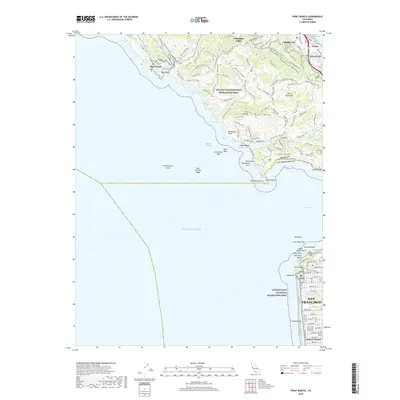
2018 Map of Point Bonita
USGS Topo · Published 2018About this map
Point Bonita stands as the sentinel at the northern entrance to the Golden Gate, anchoring a landscape where the Pacific meets the urban edge of Northern California. This coastal survey documents the extensive preserved lands of the Golden Gate National Recreation Area, showing an intricate network of paths such as the Miwok Trail and Coastal Trail that traverse the ridges above Tennessee Cove and Rodeo Cove. The transition from the dense residential grid of the Sunset District and San Francisco to the windswept headlands of the Marin Peninsula is strikingly illustrated, divided by the turbulent waters of the Bonita Channel.
Find a feature on this map
122 named features on this map. Tap any name to fly to it.
Don’t see what you’re looking for? This feature index may not catch every label — zoom into the map to look around manually.
Map Details
Editions of this 2018 Point Bonita Map
This is the sole edition of this map. No revisions or reprints were ever made.
Other maps of this area

1892 · San Mateo
USGS Topo · 1:62,500

1895 · San Francisco
USGS Topo · 1:62,500

1896 · San Mateo
USGS Topo · 1:62,500

1897 · Tamalpais
USGS Topo · 1:62,500

1899 · San Francisco
USGS Topo · 1:62,500

1899 · San Mateo
USGS Topo · 1:62,500

1915 · San Mateo
USGS Topo · 1:62,500

1915 · San Francisco
USGS Topo · 1:62,500

1939 · San Mateo
USGS Topo · 1:62,500

1941 · Tamalpais
USGS Topo · 1:62,500