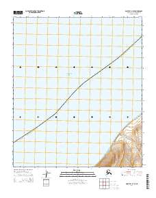
2014 Map of Point Lay A-4 SE
USGS Topo · Published 2014About this map
Chukchi Sea waters dominate this coastal survey of the far northwestern Arctic, where the coastline meets the land at the distinctive protrusion of Cape Beaufort. The map illustrates a stark transition from the open sea to the sharp rising elevations of the North Slope. Two primary watercourses, Kahkatak Cr and Tuluak Cr, drain the coastal highlands and empty into the sea just south of the cape. The survey meticulously documents the Public Land Survey System grid, including townships t5s r50w and t5s r51w, providing a precise spatial record of this remote maritime frontier. The terrain detail reveals the drainage patterns and coastal bluffs that characterize this section of the Alaskan wilderness before it reaches the deeper interior mountains.
Find a feature on this map
8 named features on this map. Tap any name to fly to it.
Don’t see what you’re looking for? This feature index may not catch every label — zoom into the map to look around manually.
Map Details
Editions of this 2014 Point Lay A-4 SE Map
This is the sole edition of this map. No revisions or reprints were ever made.
Other maps of this area

1951 · De Long Mountains
USGS Topo · 1:250,000

1951 · Point Lay
USGS Topo · 1:250,000

1955 · De Long Mountains
USGS Topo · 1:250,000

1955 · Point Lay
USGS Topo · 1:250,000
1955 · Point Lay A-3 & 4
USGS Topo · 1:63,360
1955 · De Long Mountains D-3
USGS Topo · 1:63,360

1955 · De Long Mountains D-4
USGS Topo · 1:63,360

1965 · Point Lay
USGS Topo · 1:250,000

1965 · De Long Mountains
USGS Topo · 1:250,000
2014 · Point Lay A-3 SW
USGS Topo · 1:25,000