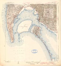
1942 Map of Point Loma
USGS Topo · Published 1942About this map
San Diego Bay dominates this early 1940s landscape, serving as a hub for military and municipal activity just as the region became a critical defense center. The U S Naval Reservation spans the waters at Dutch Flat and North Island, while Fort Rosecrans Military Reservation occupies the heights of Point Loma. The street grids of Coronado and San Diego are detailed with meticulous care, noting the locations of several neighborhood landmarks like the Coronado Country Club and the seasonal Tent City along the Silver Strand.
Find a feature on this map
79 named features on this map. Tap any name to fly to it.
Don’t see what you’re looking for? This feature index may not catch every label — zoom into the map to look around manually.
Map Details
Editions of this 1942 Point Loma Map
2 editions found
Other maps of this area

1903 · La Jolla
USGS Topo · 1:62,500

1904 · San Diego
USGS Topo · 1:62,500

1904 · Southern California Sheet No. 2
USGS Topo · 1:250,000

1930 · La Jolla
USGS Topo · 1:62,500

1930 · San Diego
USGS Topo · 1:62,500
1942 · La Mesa
USGS Topo · 1:31,680

1942 · Point Loma
USGS Topo · 1:31,680

1943 · La Jolla
USGS Topo · 1:31,680
1943 · San Ysidro
USGS Topo · 1:31,680
1944 · National City
USGS Topo · 1:31,680