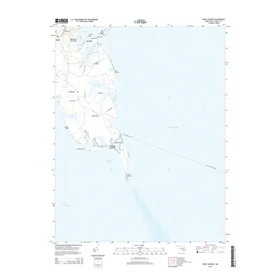
2014 Map of Point Lookout
USGS Topo · Published 2014About this map
Point Lookout anchors the southern tip of St. Mary's County where the Potomac River meets the Chesapeake Bay. This coastal landscape is defined by its low-lying marshes and numerous inlets, including Deep Creek and Biscoe Creek, which carve out distinct peninsulas like Long Neck and Fresh Pond Neck. The map documents a geography of memory and maritime life, featuring the Point Lookout Confederate Cem and the small coastal settlements of Scotland and Airedale. Along the western shore, the high ground of Wailes Bluff and Portneys Overlook provides a contrast to the complex hydrology of Hall Pond and the tidal reaches of Southern Prong Saint Jerome Creek. The inclusion of the Point Lookout-Ewell Fry route indicates the area's ongoing role as a transportation node across the bay's open waters.
Find a feature on this map
33 named features on this map. Tap any name to fly to it.
Don’t see what you’re looking for? This feature index may not catch every label — zoom into the map to look around manually.
Map Details
Editions of this 2014 Point Lookout Map
This is the sole edition of this map. No revisions or reprints were ever made.
Other maps of this area

1894 · Point Lookout
USGS Topo · 1:62,500

1898 · St. Marys
USGS Topo · 1:125,000

1903 · Bloodsworth Island
USGS Topo · 1:62,500

1906 · St. Marys
USGS Topo · 1:125,000

1912 · Point Lookout
USGS Topo · 1:62,500

1917 · Heathsville
USGS Topo · 1:48,000

1917 · Ewell
USGS Topo · 1:62,500

1937 · Point Lookout
USGS Topo · 1:62,500

1942 · Richland Point
USGS Topo · 1:24,000
1942 · Point Lookout
USGS Topo · 1:24,000