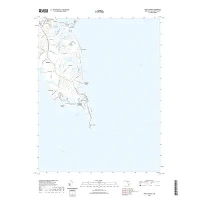
2019 Map of Point Lookout
USGS Topo · Published 2019About this map
Point Lookout marks the southernmost tip of the peninsula where the Potomac River meets the Chesapeake Bay. This maritime landscape is defined by its deep inlets and tidal prongs, including Saint Jerome Creek and Cornfield Harbor. The settlement patterns here follow the high ground along Point Lookout Rd, connecting the communities of Ridge, Airedele, and Scotland. In the northern section, the Saint Michael Parish Cem stands as a local genealogical landmark near the headwaters of the Northern Prong Saint Jerome Creek.
Find a feature on this map
59 named features on this map. Tap any name to fly to it.
Don’t see what you’re looking for? This feature index may not catch every label — zoom into the map to look around manually.
Map Details
Editions of this 2019 Point Lookout Map
This is the sole edition of this map. No revisions or reprints were ever made.
Other maps of this area

1894 · Point Lookout
USGS Topo · 1:62,500

1898 · St. Marys
USGS Topo · 1:125,000

1903 · Bloodsworth Island
USGS Topo · 1:62,500

1906 · St. Marys
USGS Topo · 1:125,000

1912 · Point Lookout
USGS Topo · 1:62,500

1917 · Heathsville
USGS Topo · 1:48,000

1917 · Ewell
USGS Topo · 1:62,500

1937 · Point Lookout
USGS Topo · 1:62,500

1942 · Richland Point
USGS Topo · 1:24,000
1942 · Point Lookout
USGS Topo · 1:24,000