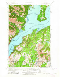
1936 Map of Point Misery
USGS Topo · Published 1964About this map
The Toandos Peninsula and the deep waters of Dabop Bay dominate this pre-war survey of the central Hood Canal region. The landscape is defined by the transition from the rugged eastern edge of the Olympic National Forest to the small timber and maritime settlements along the shoreline. Evidence of the era's local industry is visible at the Lewis Lumber Co near Crosby, while the US Fish Hatchery Duckabush Station reflects early conservation efforts on the Duckabush River.
Find a feature on this map
67 named features on this map. Tap any name to fly to it.
Don’t see what you’re looking for? This feature index may not catch every label — zoom into the map to look around manually.
Map Details
Editions of this 1936 Point Misery Map
3 editions found
Other maps of this area

1936 · Point Misery
USGS Topo · 1:62,500

1937 · Port Orchard
USGS Topo · 1:62,500

1937 · Port Gamble
USGS Topo · 1:62,500

1938 · Mt Constance
USGS Topo · 1:125,000

1938 · Allyn
USGS Topo · 1:62,500

1940 · Port Gamble
USGS Topo · 1:62,500

1940 · Point Misery
USGS Topo · 1:62,500

1940 · Quilcene
USGS Topo · 1:62,500

1942 · Gig Harbor
USGS Topo · 1:62,500

1943 · Potlatch
USGS Topo · 1:62,500