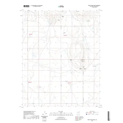
2020 Map of Point of Rocks Mesa
USGS Topo · Published 2020About this map
Point of Rocks Mesa rises as a prominent landmark in this section of Colfax County, where the high plains meet the intricate drainage systems of the Canadian River watershed. The settlement of Chico serves as a focal point in a landscape defined by seasonal watercourses like Joe Cabin Arroyo and W Hills Arroyo. This 2020 survey illustrates a network of county roads, such as Chico Rd and Point of Rocks Rd, that weave between geological features including Hogback Butte and Black Hill. Local history is anchored by the Hollenbeck Cem and numerous named water sources like Chico Springs and Middle Water Springs, which were essential for ranching and early travel. The topography is deeply incised by multiple canyons, including Blackjack Canyon and Goldmine Canyon, reflecting the area's complex erosion patterns and ranching heritage.
Find a feature on this map
41 named features on this map. Tap any name to fly to it.
Don’t see what you’re looking for? This feature index may not catch every label — zoom into the map to look around manually.
Map Details
Editions of this 2020 Point of Rocks Mesa Map
This is the sole edition of this map. No revisions or reprints were ever made.
Other maps of this area

1954 · Raton
USGS Topo · 1:250,000

1958 · Raton
USGS Topo · 1:250,000

1965 · Sauble Circle Dot Ranch
USGS Topo · 1:24,000

1965 · Abbott
USGS Topo · 1:24,000

1971 · Tres Hermanos Peak
USGS Topo · 1:24,000

1971 · Pine Buttes
USGS Topo · 1:24,000

1971 · Palo Blanco Mountain
USGS Topo · 1:24,000

1974 · Point Of Rocks Mesa
USGS Topo · 1:24,000

1974 · Farley
USGS Topo · 1:24,000
1974 · Lawrence Arroyo
USGS Topo · 1:24,000