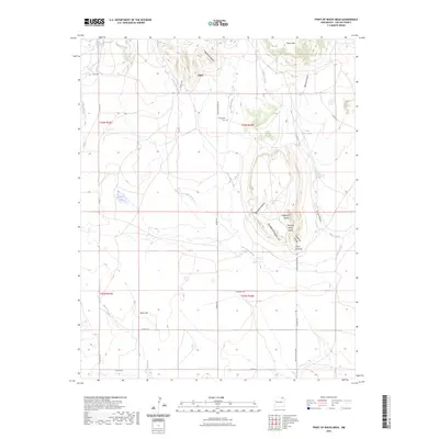
2023 Map of Point of Rocks Mesa
USGS Topo · Published 2023About this map
Point of Rocks Mesa dominates the central landscape of this Colfax County quadrangle, rising above a network of arroyos and canyons. To its south and east, the land is etched by Joe Cabin Arroyo, Goldmine Canyon, and Strong Canyon, reflecting a terrain where seasonal water flow has carved deep paths through the high plains. The settlement of Chico and the nearby Chico Springs represent the area's historical reliance on these scarce water sources. The map documents a sparsely populated ranching landscape where isolated landmarks like Hogback Butte and Black Hill serve as primary navigational points across the open range.
Find a feature on this map
38 named features on this map. Tap any name to fly to it.
Don’t see what you’re looking for? This feature index may not catch every label — zoom into the map to look around manually.
Map Details
Editions of this 2023 Point of Rocks Mesa Map
This is the sole edition of this map. No revisions or reprints were ever made.
Other maps of this area

1954 · Raton
USGS Topo · 1:250,000

1958 · Raton
USGS Topo · 1:250,000

1965 · Sauble Circle Dot Ranch
USGS Topo · 1:24,000

1965 · Abbott
USGS Topo · 1:24,000

1971 · Tres Hermanos Peak
USGS Topo · 1:24,000

1971 · Pine Buttes
USGS Topo · 1:24,000

1971 · Palo Blanco Mountain
USGS Topo · 1:24,000

1974 · Point Of Rocks Mesa
USGS Topo · 1:24,000

1974 · Farley
USGS Topo · 1:24,000
1974 · Lawrence Arroyo
USGS Topo · 1:24,000