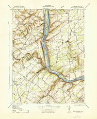
1943 Map of Point Pleasant
USGS Topo · Published 1943About this map
The Delaware River defines this 1943 landscape, serving as both a state boundary and a corridor for industry and transport. Along the New Jersey bank, the Pennsylvania Railroad Belvidere Division tracks the river, connecting riverside hamlets like Byram and Raven Rock. Across the water in Pennsylvania, the map reveals a community-centered landscape marked by early education and industry, including Plumstead School No 10 and the Township Stone Quarry.
Find a feature on this map
68 named features on this map. Tap any name to fly to it.
Don’t see what you’re looking for? This feature index may not catch every label — zoom into the map to look around manually.
Map Details
Editions of this 1943 Point Pleasant Map
This is the sole edition of this map. No revisions or reprints were ever made.
Other maps of this area

1890 · Easton
USGS Topo · 1:62,500

1890 · High Bridge
USGS Topo · 1:62,500

1890 · Lambertville
USGS Topo · 1:62,500

1890 · Doylestown
USGS Topo · 1:62,500

1891 · Easton
USGS Topo · 1:62,500

1891 · Lambertville
USGS Topo · 1:62,500

1891 · Doylestown
USGS Topo · 1:62,500

1894 · Lambertville
USGS Topo · 1:62,500

1898 · High Bridge
USGS Topo · 1:62,500

1900 · Raritan
USGS Topo · 1:125,000
Featured Places
- Buckingham Township, PA
- Solebury Township, PA
- Bedminster Township, PA
- Tinicum Township, PA
- Kingwood Township, NJ