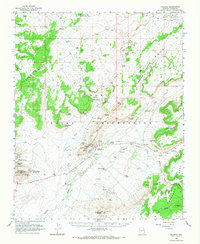
1966 Map of Polacca
USGS Topo · Published 1987About this map
Hopi Indian Reservation mesa-top villages and canyon settlements are documented here in the mid-1960s. The traditional First Mesa villages of Hano, Sichomovi, and Walpi crown the narrow sandstone ridge, while the newer community of Polacca sits at the base. To the west on Second Mesa, the settlements of Shungopovi, Mishongnovi, and Toreva are positioned near the Sunlight Mission. This period captures the landscape during the existence of the Navajo-Hopi Joint Use Area, showing a network of springs and washes critical to the region's life, including Onion Spring, Wepo Spring, and Flower Spring. The settlement pattern follows the drainages of Wepo Wash and Polacca Wash, where isolated features like Five Houses and the Keams Canyon government outpost serve as local landmarks amidst the Sand Hills and deep cuts of Cottonwood Canyon.
Find a feature on this map
101 named features on this map. Tap any name to fly to it.
Don’t see what you’re looking for? This feature index may not catch every label — zoom into the map to look around manually.
Map Details
Editions of this 1966 Polacca Map
This is the sole edition of this map. No revisions or reprints were ever made.
Other maps of this area

1883 · Marsh Pass
USGS Topo · 1:250,000

1883 · Tusayan
USGS Topo · 1:250,000

1886 · Tusayan
USGS Topo · 1:250,000

1892 · Marsh Pass
USGS Topo · 1:250,000

1947 · Flagstaff
USGS Topo · 1:250,000

1954 · Flagstaff
USGS Topo · 1:250,000

1956 · Marble Canyon
USGS Topo · 1:250,000

1958 · Flagstaff
USGS Topo · 1:250,000

1959 · Marble Canyon
USGS Topo · 1:250,000

1960 · Flagstaff
USGS Topo · 1:250,000