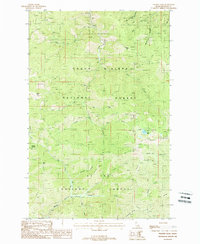
1988 Map of Polaris Peak
USGS Topo · Published 1988About this map
The steep terrain of the Idaho panhandle's mining country is the focus of this late-twentieth-century study, where the Coeur d'Alene National Forest meets the St Joe National Forest. The landscape is dominated by the high points of Polaris Peak and Silver Hill, defined by a dense network of extraction sites including numerous labeled prospects and an Adit. This concentration of mining activity, particularly around Mc Farren Gulch and the ridges above Big Creek, indicates the ongoing mineral exploration and timber management that shaped the region's economy.
Find a feature on this map
30 named features on this map. Tap any name to fly to it.
Don’t see what you’re looking for? This feature index may not catch every label — zoom into the map to look around manually.
Map Details
Editions of this 1988 Polaris Peak Map
This is the sole edition of this map. No revisions or reprints were ever made.
Other maps of this area

1901 · Coeur D'Alene District
USGS Topo · 1:62,500

1903 · Coeur D'Alene District
USGS Topo · 1:62,500

1906 · Coeur D'Alene District
USGS Topo · 1:62,500

1909 · Cataldo
USGS Topo · 1:125,000

1911 · Cataldo
USGS Topo · 1:125,000

1914 · Avery
USGS Topo · 1:125,000

1917 · Avery
USGS Topo · 1:125,000

1932 · Trout Creek
USGS Topo · 1:125,000

1935 · Trout Creek
USGS Topo · 1:125,000

1936 · Trout Creek
USGS Topo · 1:125,000