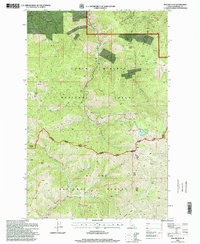
1996 Map of Polaris Peak
USGS Topo · Published 1999About this map
Polaris Peak rises as the central topographic feature of this high-elevation terrain on the border of the Coeur d'Alene National Forest and St Joe National Forest. The landscape is defined by the headwaters of numerous drainages, including the West Fork Rosebud Gulch and the Middle Fork Big Creek, which cut through a region dominated by timber and extraction. Human activity is evidenced by numerous prospects, adits, and gravel pits scattered throughout the gulches, reflecting the mining history of Shoshone County. For the recreationist and local researcher, the map details established routes such as the Bronson Meadows Trail and the Recreation Trail that navigate the ridges between summits like Silver Hill and Elsie Peak. A solitary Cemetery near the northern boundary and the quiet waters of Elsie Lake provide specific points of interest in this heavily forested mountain interior.
Find a feature on this map
31 named features on this map. Tap any name to fly to it.
Don’t see what you’re looking for? This feature index may not catch every label — zoom into the map to look around manually.
Map Details
Editions of this 1996 Polaris Peak Map
This is the sole edition of this map. No revisions or reprints were ever made.
Other maps of this area

1901 · Coeur D'Alene District
USGS Topo · 1:62,500

1903 · Coeur D'Alene District
USGS Topo · 1:62,500

1906 · Coeur D'Alene District
USGS Topo · 1:62,500

1909 · Cataldo
USGS Topo · 1:125,000

1911 · Cataldo
USGS Topo · 1:125,000

1914 · Avery
USGS Topo · 1:125,000

1917 · Avery
USGS Topo · 1:125,000

1932 · Trout Creek
USGS Topo · 1:125,000

1935 · Trout Creek
USGS Topo · 1:125,000

1936 · Trout Creek
USGS Topo · 1:125,000