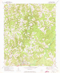
1970 Map of Polkton
USGS Topo · Published 1973About this map
Polkton and the surrounding rural communities of Anson County are defined by a complex network of waterways that shaped early settlement patterns. In the south, the Seaboard Coast Line railroad serves as the primary industrial corridor, passing near a Water Tank and several Quarry sites. The landscape is dotted with small agricultural hubs and family-named landmarks like Griffins Crossroads, Sugar Town, and Kikers, suggesting a region where local geography and community identity are closely linked.
Find a feature on this map
38 named features on this map. Tap any name to fly to it.
Don’t see what you’re looking for? This feature index may not catch every label — zoom into the map to look around manually.
Map Details
Editions of this 1970 Polkton Map
This is the sole edition of this map. No revisions or reprints were ever made.
Other maps of this area

1941 · Spartanburg
USGS Topo · 1:250,000

1953 · Spartanburg
USGS Topo · 1:250,000

1953 · Charlotte
USGS Topo · 1:250,000

1954 · Charlotte
USGS Topo · 1:250,000

1956 · Ansonville
USGS Topo · 1:24,000

1956 · Mount Gilead West
USGS Topo · 1:24,000

1956 · Wadesboro
USGS Topo · 1:24,000

1960 · Charlotte
USGS Topo · 1:250,000

1960 · Spartanburg
USGS Topo · 1:250,000

1962 · Charlotte
USGS Topo · 1:250,000