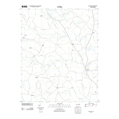
2010 Map of Polkville
USGS Topo · Published 2010About this map
Polkville and the surrounding rural communities of Cleveland County are defined by a landscape of rolling foothills and prominent peaks such as Jack Moore Mountain and Tom Price Mountain. The First Broad River snakes through the northern and eastern portions of the quadrangle, joined by a dense network of tributaries including Duncans Creek and Hinton Creek. This 2010 survey shows the area's transition from a strictly agricultural base to one supporting more modern infrastructure, evidenced by the Cleveland Airport located near the southeastern corner.
Find a feature on this map
91 named features on this map. Tap any name to fly to it.
Don’t see what you’re looking for? This feature index may not catch every label — zoom into the map to look around manually.
Map Details
Editions of this 2010 Polkville Map
This is the sole edition of this map. No revisions or reprints were ever made.
Other maps of this area

1905 · Morganton
USGS Topo · 1:125,000

1950 · Shelby
USGS Topo · 1:62,500

1953 · Charlotte
USGS Topo · 1:250,000

1954 · Charlotte
USGS Topo · 1:250,000

1956 · Benn Knob
USGS Topo · 1:24,000

1956 · Casar
USGS Topo · 1:24,000

1960 · Charlotte
USGS Topo · 1:250,000

1962 · Charlotte
USGS Topo · 1:250,000
1962 · Dysartsville
USGS Topo · 1:24,000
1965 · Sunshine
USGS Topo · 1:24,000