
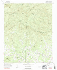
1956 Map of Benn Knob
USGS Topo · Published 1958About this map
South Mountains terrain dominates this mid-century survey of the rugged borderlands where Burke, Rutherford, and Cleveland Counties meet. The landscape is defined by its deep forks and named peaks like Benn Knob and Hickorynut Mtn. In the lower elevations, particularly within Golden Valley and along the First Broad River, the map records the community structures of the 1950s. Rural life is anchored by family-centered institutions, evidenced by the cluster of the Mt Moriah Ch, Mt Moriah Cem, and Moriah Sch. Unlike the densely settled valleys further south, this area maintains a remote character, with most roads following the narrow creek beds or winding through gaps like Woods Gap and Gibbs Gap. The drainage patterns of the Henry Fork and Jacob Fork illustrate the complex watershed that directed early settlement and movement through these upland gaps.
Find a feature on this map
67 named features on this map. Tap any name to fly to it.
Don’t see what you’re looking for? This feature index may not catch every label — zoom into the map to look around manually.
Map Details
Editions of this 1956 Benn Knob Map
2 editions found
Other maps of this area

1905 · Morganton
USGS Topo · 1:125,000

1950 · Shelby
USGS Topo · 1:62,500

1953 · Charlotte
USGS Topo · 1:250,000

1954 · Charlotte
USGS Topo · 1:250,000

1956 · Valdese
USGS Topo · 1:24,000

1956 · Casar
USGS Topo · 1:24,000

1956 · Morganton South
USGS Topo · 1:24,000

1960 · Charlotte
USGS Topo · 1:250,000

1962 · Charlotte
USGS Topo · 1:250,000
1962 · Glen Alpine
USGS Topo · 1:24,000