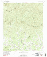
1956 Map of Benn Knob
USGS Topo · Published 1984About this map
The Upper Fork Mountains and the Lower Fork range dominate this landscape, meeting at the borders of Burke, Rutherford, and Cleveland Counties. The 1950s terrain reveals a pocket of rural settlement concentrated along the Broad River and its northern tributaries like Brier Creek and No Business creek. This area is characterized by family-oriented landmarks and small community hubs, particularly in the south where the Moriah Sch and Mt Moriah Ch stand as local anchors. In the western reaches, the names Richland Valley and Golden Valley hint at the historical agricultural and potential prospecting value of the region. Transportation at this time was limited to winding valley roads and a Jeep Trail crossing the ridges between peaks such as Benn Knob and Hickorynut Mtn.
Find a feature on this map
67 named features on this map. Tap any name to fly to it.
Don’t see what you’re looking for? This feature index may not catch every label — zoom into the map to look around manually.
Map Details
Editions of this 1956 Benn Knob Map
2 editions found
Other maps of this area

1905 · Morganton
USGS Topo · 1:125,000

1950 · Shelby
USGS Topo · 1:62,500

1953 · Charlotte
USGS Topo · 1:250,000

1954 · Charlotte
USGS Topo · 1:250,000

1956 · Valdese
USGS Topo · 1:24,000

1956 · Benn Knob
USGS Topo · 1:24,000

1956 · Casar
USGS Topo · 1:24,000

1956 · Morganton South
USGS Topo · 1:24,000

1960 · Charlotte
USGS Topo · 1:250,000

1962 · Charlotte
USGS Topo · 1:250,000