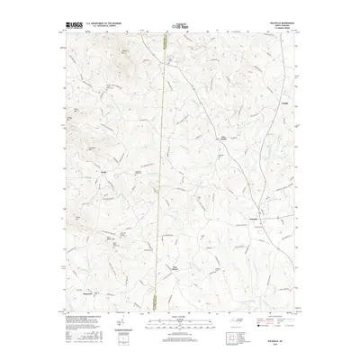
2016 Map of Polkville
USGS Topo · Published 2016About this map
Polkville and the surrounding rural communities of Hollis and New House anchor this 2016 survey along the Rutherford and Cleveland County line. The landscape is characterized by a series of prominent peaks, including Lisenberry Mtn, Piney Mtn, and Jack Moore Mtn, which define the drainage basins for numerous local waterways. The First Broad River travels through the eastern portion of the quadrangle, joined by tributaries such as Hinton Cr and Big Springs Br. This map is particularly valuable for genealogical research, as it identifies several established community centers and burial grounds. Notable landmarks include the Lee Chapel Cem, White Oak Springs Church Cem, and the Mount Olivet Church Cem. The distribution of these churches and cemeteries alongside older routes like Old Lincolnton Rd and W Stage Coach Trl illustrates the persistent settlement patterns of this North Carolina piedmont region.
Find a feature on this map
129 named features on this map. Tap any name to fly to it.
Don’t see what you’re looking for? This feature index may not catch every label — zoom into the map to look around manually.
Map Details
Editions of this 2016 Polkville Map
This is the sole edition of this map. No revisions or reprints were ever made.
Other maps of this area

1905 · Morganton
USGS Topo · 1:125,000

1950 · Shelby
USGS Topo · 1:62,500

1953 · Charlotte
USGS Topo · 1:250,000

1954 · Charlotte
USGS Topo · 1:250,000

1956 · Benn Knob
USGS Topo · 1:24,000

1956 · Casar
USGS Topo · 1:24,000

1960 · Charlotte
USGS Topo · 1:250,000

1962 · Charlotte
USGS Topo · 1:250,000
1962 · Dysartsville
USGS Topo · 1:24,000
1965 · Sunshine
USGS Topo · 1:24,000