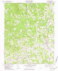
1982 Map of Polkville
USGS Topo · Published 1983About this map
Polkville sits at the eastern edge of this landscape where the Piedmont begins to rise toward the foothills, marked by the winding course of the First Broad River. In the early 1980s, the region was characterized by small, dispersed rural settlements and a dense network of community landmarks. Numerous country churches like Mt Olive Ch, Duncans Creek Ch, and Brooks Chapel served as the anchors for local life, often situated near family-named landmarks such as Jack Moore Mountain and Tom Price Mountain.
Find a feature on this map
54 named features on this map. Tap any name to fly to it.
Don’t see what you’re looking for? This feature index may not catch every label — zoom into the map to look around manually.
Map Details
Editions of this 1982 Polkville Map
This is the sole edition of this map. No revisions or reprints were ever made.
Other maps of this area

1905 · Morganton
USGS Topo · 1:125,000

1950 · Shelby
USGS Topo · 1:62,500

1953 · Charlotte
USGS Topo · 1:250,000

1954 · Charlotte
USGS Topo · 1:250,000

1956 · Benn Knob
USGS Topo · 1:24,000

1956 · Casar
USGS Topo · 1:24,000

1960 · Charlotte
USGS Topo · 1:250,000

1962 · Charlotte
USGS Topo · 1:250,000
1962 · Dysartsville
USGS Topo · 1:24,000
1965 · Sunshine
USGS Topo · 1:24,000