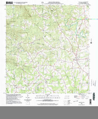
2002 Map of Polkville
USGS Topo · Published 2003About this map
The First Broad River meanders through this portion of the Piedmont, defining a landscape of small agricultural settlements and wooded ridges on the border of Cleveland and Rutherford counties. Small communities like Polkville and Hollis serve as anchors for a network of country roads connecting numerous family-named landmarks and places of worship. The map reveals a dense concentration of local heritage sites, including the Palmera Grove Ch and White Oak Springs Ch, alongside several family burial grounds such as Lattimore Cem and Crowder Cem.
Find a feature on this map
64 named features on this map. Tap any name to fly to it.
Don’t see what you’re looking for? This feature index may not catch every label — zoom into the map to look around manually.
Map Details
Editions of this 2002 Polkville Map
This is the sole edition of this map. No revisions or reprints were ever made.
Other maps of this area

1905 · Morganton
USGS Topo · 1:125,000

1950 · Shelby
USGS Topo · 1:62,500

1953 · Charlotte
USGS Topo · 1:250,000

1954 · Charlotte
USGS Topo · 1:250,000

1956 · Benn Knob
USGS Topo · 1:24,000

1956 · Casar
USGS Topo · 1:24,000

1960 · Charlotte
USGS Topo · 1:250,000

1962 · Charlotte
USGS Topo · 1:250,000
1962 · Dysartsville
USGS Topo · 1:24,000
1965 · Sunshine
USGS Topo · 1:24,000