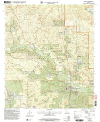
2003 Map of Pollock
USGS Topo · Published 2005About this map
Kisatchie National Forest dominates the landscape of Grant Parish in this early 21st-century record, where timber management and conservation efforts are evident through features like the Stuart Pine Seed Orchard and Catahoula Ranger Station. The town of Pollock serves as a local hub, situated near the winding course of Big Creek and Sandy Creek. To the west, Bentley sits along a transport corridor, while smaller settlements such as Antonia, Subeta, and Sand Spur reflect the rural development patterns of the region.
Find a feature on this map
34 named features on this map. Tap any name to fly to it.
Don’t see what you’re looking for? This feature index may not catch every label — zoom into the map to look around manually.
Map Details
Editions of this 2003 Pollock Map
This is the sole edition of this map. No revisions or reprints were ever made.
Other maps of this area

1932 · Colfax NE
USGS Topo · 1:31,680

1932 · Boyce NE
USGS Topo · 1:31,680

1932 · Colfax SE
USGS Topo · 1:31,680

1936 · Colfax
USGS Topo · 1:62,500

1936 · Pollock
USGS Topo · 1:62,500

1941 · Alexandria
USGS Topo · 1:62,500

1941 · Pollock
USGS Topo · 1:62,500

1941 · Boyce
USGS Topo · 1:62,500

1953 · Alexandria
USGS Topo · 1:250,000

1955 · Alexandria
USGS Topo · 1:250,000