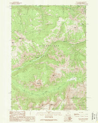
1989 Map of Pollux Peak
USGS Topo · Published 1989About this map
Yellowstone National Park and the North Absaroka Wilderness converge in this high-altitude landscape documented during the late 1980s. The region is defined by a dense concentration of summits, including the twin heights of Pollux Peak and Castor Peak, which tower over the drainage of the Lamar River. This environment required specialized infrastructure for management and monitoring, evidenced by the Upper Lamar River Patrol Station and the Upper Miller Creek Patrol Station located near the park boundaries. Navigation through the steep drainages of Red Creek and the Little Lamar River relied on a network of a Pack Trail, illustrating how the backcountry was accessed and patrolled before modern development. The map also records landmarks such as Saddle Mountain and Parker Peak, which overlook the Hoodoo Basin on the eastern edge of the Shoshone National Forest.
Find a feature on this map
19 named features on this map. Tap any name to fly to it.
Don’t see what you’re looking for? This feature index may not catch every label — zoom into the map to look around manually.
Map Details
Editions of this 1989 Pollux Peak Map
This is the sole edition of this map. No revisions or reprints were ever made.
Other maps of this area

1886 · Canyon
USGS Topo · 1:125,000

1895 · Canyon
USGS Topo · 1:125,000

1896 · Canyon
USGS Topo · 1:125,000

1896 · Crandall Creek
USGS Topo · 1:125,000

1899 · Crandall
USGS Topo · 1:125,000

1901 · Canyon
USGS Topo · 1:125,000

1907 · Canyon
USGS Topo · 1:125,000

1911 · Canyon
USGS Topo · 1:125,000

1955 · Ashton
USGS Topo · 1:250,000

1955 · Cody
USGS Topo · 1:250,000