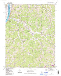
1994 Map of Pond Creek
USGS Topo · Published 1998About this map
Belleville and Reedsville anchor this mid-1990s landscape, situated along a prominent bend of the Ohio River where the Belleville Lock and Dam controls the waterway's flow. The riverfront is characterized by Olive Bottom and the presence of the Baltimore and Ohio RR, highlighting the region's historic dependence on both rail and water transport. In the rugged interior, the terrain is defined by Dutch Ridge and Cabin Ridge, with a high density of small family cemeteries and rural churches serving dispersed communities like Milhoan and Utica.
Find a feature on this map
101 named features on this map. Tap any name to fly to it.
Don’t see what you’re looking for? This feature index may not catch every label — zoom into the map to look around manually.
Map Details
Editions of this 1994 Pond Creek Map
This is the sole edition of this map. No revisions or reprints were ever made.
Other maps of this area

1906 · Belleville
USGS Topo · 1:62,500

1907 · Keno
USGS Topo · 1:62,500

1907 · Ripley
USGS Topo · 1:62,500

1908 · Ravenswood
USGS Topo · 1:62,500

1924 · Belleville
USGS Topo · 1:62,500

1926 · Ravenswood
USGS Topo · 1:62,500

1926 · Belleville
USGS Topo · 1:62,500

1926 · Ripley
USGS Topo · 1:62,500

1928 · Ravenswood
USGS Topo · 1:62,500

1928 · Ripley
USGS Topo · 1:62,500