
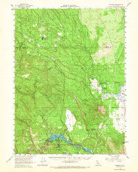
1961 Map of Pondosa
USGS Topo · Published 1963About this map
The McCloud River and Fall River define this mid-century landscape on the border of Siskiyou and Shasta Counties. The settlement of Pondosa serves as a hub for the surrounding Shasta National Forest, connected to outlying points like Harlow Place and Spalding Corner. Logging and infrastructure are evident through an extensive network of Railroad Grades and an Aqueduct system near Camp Nine Flat.
Find a feature on this map
60 named features on this map. Tap any name to fly to it.
Don’t see what you’re looking for? This feature index may not catch every label — zoom into the map to look around manually.
Map Details
Editions of this 1961 Pondosa Map
2 editions found
Other maps of this area

1886 · Lassen Peak
USGS Topo · 1:250,000

1886 · Modoc Lava Bed
USGS Topo · 1:250,000

1892 · Modoc Lava-Bed
USGS Topo · 1:250,000

1892 · Lassen Peak
USGS Topo · 1:250,000

1894 · Lassen Peak
USGS Topo · 1:250,000

1932 · Bartle
USGS Topo · 1:96,000

1935 · Burney
USGS Topo · 1:96,000

1939 · Burney
USGS Topo · 1:125,000

1939 · Halls Flat
USGS Topo · 1:125,000

1939 · Bartle
USGS Topo · 1:125,000