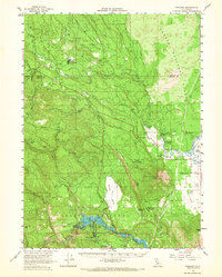
1961 Map of Pondosa
USGS Topo · Published 1967About this map
Lake Britton and the surrounding timberlands of the Shasta National Forest dominate this early 1960s landscape at the intersection of Siskiyou and Shasta Counties. The map documents a transition in local transportation and industry, featuring an extensive network of railroad grades and old railroad grades that once serviced the logging camps and mills of the region. Small settlements like Pondosa and Dana serve as focal points for local history, with the latter containing the Dana Cem near the Fall River. To the south, the McArthur-Burney Falls Memorial State Park protects the dramatic geology of Burney Falls, while the hydroelectric infrastructure of the Pit River system is evident through various gaging stations and a large aqueduct near Camp Nine Flat. High-elevation landmarks such as Soldier Mtn, with its Soldier Mtn Lookout, provide a clear sense of the vertical terrain overlooking Cayton Valley.
Find a feature on this map
71 named features on this map. Tap any name to fly to it.
Don’t see what you’re looking for? This feature index may not catch every label — zoom into the map to look around manually.
Map Details
Editions of this 1961 Pondosa Map
2 editions found

Other maps of this area

1886 · Lassen Peak
USGS Topo · 1:250,000

1886 · Modoc Lava Bed
USGS Topo · 1:250,000

1892 · Modoc Lava-Bed
USGS Topo · 1:250,000

1892 · Lassen Peak
USGS Topo · 1:250,000

1894 · Lassen Peak
USGS Topo · 1:250,000

1932 · Bartle
USGS Topo · 1:96,000

1935 · Burney
USGS Topo · 1:96,000

1939 · Burney
USGS Topo · 1:125,000

1939 · Halls Flat
USGS Topo · 1:125,000

1939 · Bartle
USGS Topo · 1:125,000