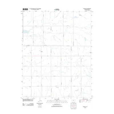
2012 Map of Pontiac
USGS Topo · Published 2012About this map
Pontiac serves as the central hub of this Butler County landscape, situated amidst an extensive network of rural section roads and creek drainages. The area is defined by its transition from the shores of El Dorado Lake in the northwest to the active petroleum extraction sites of the Long Oil Field and Young Oil Field further south. Genealogists will find historical value in the presence of the Pontiac Cem and the Economy Cem, which are tucked away near Bird Cr and Turkey Cr. The terrain is deeply etched by numerous waterways, including Bemis Cr, Harrison Cr, and the N Br Little Walnut River, illustrating the natural drainage patterns that have shaped local agriculture and settlement. The inclusion of Foster Field Airport in the northeast highlights the integration of modern transportation within this traditional prairie setting.
Find a feature on this map
34 named features on this map. Tap any name to fly to it.
Don’t see what you’re looking for? This feature index may not catch every label — zoom into the map to look around manually.
Map Details
Editions of this 2012 Pontiac Map
This is the sole edition of this map. No revisions or reprints were ever made.
Other maps of this area

1888 · Eldorado
USGS Topo · 1:125,000

1955 · Wichita
USGS Topo · 1:250,000

1958 · Wichita
USGS Topo · 1:250,000

1961 · Pontiac
USGS Topo · 1:24,000

1961 · De Graff
USGS Topo · 1:24,000

1961 · Rosalia NE
USGS Topo · 1:24,000

1961 · El Dorado
USGS Topo · 1:24,000

1961 · Rosalia
USGS Topo · 1:24,000
1961 · Rosalia NW
USGS Topo · 1:24,000

1963 · Leon
USGS Topo · 1:24,000